Showing posts with label Zion National Park. Show all posts

Friday, June 28, 2013

Zion National Park: Exploring The Lesser Known Areas

Down through the millennia, the North Fork of the Virgin River has cut a swathe of Navajo Sandstone, nearly 15 miles long and a half-mile deep, to create what is now known as Zion Canyon. Before it became a national park, the Anasazi and the Southern Paiutes lived among the mountains, canyons, buttes, mesas, monoliths and natural arches of Zion. Spanish priests first visited the present-day park in 1776. Eventually Mormons came to the area in 1858, and would settle there by the early 1860s.

In 1909 President William Howard Taft signed legislation making Zion a national monument, which was known at that time as Mukuntuweap National Monument. In 1918 the name was changed to Zion National Monument, and in the following year was upgraded to a national park.

One of Zion’s most famous features is the death-defying hike up to Angels Landing. The trail climbs 1200 feet in roughly 2.4 miles. To reach the top hikers have to ascend Walter's Wiggles, a series of 21 steep switchbacks up to Scout Lookout. The last half-mile features sharp drop-offs along a narrow path, which includes chains for hikers to grip. The chains are there for a very good reason. In the past eight years alone six people have plunged to their death after losing their footing along this trail.

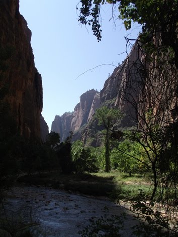
Although Zion Canyon is the main attraction, I highly recommend spending at least 2 or 3 hours exploring the area east of the Zion-Mt. Carmel Tunnel. In addition to hiking the easy half-mile trail out to Zion Canyon Overlook, there are several interesting rock formations to check out. Here are a few random photos from this strange and beautiful area of the park:


Map: Zion NP Trails Illustrated Map


Hiking Zion and Bryce Canyon National Parks covers 56 hikes in the two parks, as well as the surrounding areas, such as Cedar Breaks National Monument. From day hikes to backcountry treks, the books provides comprehensive trail descriptions, trail maps, route profiles, difficulty ratings, recommended hiking seasons, as well as invaluable trip-planning information, including a checklist of essential equipment and supplies.


Zion Canyon from Observation Point

Observation Point in Zion National Park is an absolute gem. Although there are more popular hikes in the park, such as Angels Landing, two park rangers told us that this hike was their favorite. Simply put, the trail starts off with grand views, and only gets better the higher you climb.

I highly recommend starting as early in the morning as possible in order to take advantage of the shade from the towering cliffs for a large portion of your climb.

The hike begins from the Weeping Rock Trailhead, and immediately begins climbing a series of long switchbacks up Cable Mountain. Much of this trail was blasted out of the canyon walls in the 1920s. As the trail climbs higher you’ll have stunning views of Angels Landing, The Organ, and Big Bend in the Virgin River:


At roughly 1.5 miles the trail leaves the cliff side and enters into the incredibly beautiful Echo Canyon. For the next half-mile you’ll have a nice break from the relentless climbing.


In some ways Echo Canyon was even more impressive than the views from Observation Point. This narrow canyon, sitting roughly 1100 feet above the trailhead, would make a wonderful destination by itself. The trail follows along a shelf above the canyon floor, with an extremely narrow slot canyon sitting just below it.


To get an idea of the immensity of this canyon, see if you can spot my wife at the very bottom of this photo:


Looking over the side of the trail I spotted this interesting looking hole, roughly 200 feet below:


Once out of the canyon the trail begins to climb again, and gains roughly 900 feet over the next mile. Roughly 60% of this hike has some exposure that leads to long drop-offs. However, most of the trail is at least 4-5 feet in width, with some places narrowing down to maybe three. Obviously if you have a fear of heights you’re going to feel very uncomfortable on this trail. For the most part I was able to do my normal pace, and didn’t feel any intimidation. There was one section, about a tenth-of-a-mile in length, just below the canyon rim, that did make me a little nervous. This section of the hike stands-out prominently from Observation Point. In the photo below you can see a “Z” etched into the side of the white cliff face. This is another part of the path that has been blasted out of the rock:


Other than this one short section, if you’re used to hiking in the mountains, you likely won’t have any other problems with vertigo-inducing drop-offs.

Beyond the “Z” the trail levels out for the most part, and begins to hug the forested cliffside over the course of the last mile to Observation Point.

From Observation Point you’ll have one of the great iconic images of Zion National Park. The views are simply awesome. From this vantage point Angels Landing, The Organ and Big Bend will be the most prominent landmarks almost directly below you. On the west side of the canyon you’ll see Cathedral Mountain and the Three Patriarchs. On the left is the East Rim, Cable Mountain and the Great White Throne. Running down the middle of the valley is the Virgin River as it flows towards Springdale and beyond.


Afterwards we drove into Springdale and had a great burger and an oven fired pizza from the Flying Monkey.


Trail: Observation Point
RT Distance: 8.0 Miles
Total Elevation Gain: 2150 feet
Max Elevation: 6507 Feet
TH Location: Weeping Rock Trailhead
Map: Zion NP Trails Illustrated Map


Hiking Zion and Bryce Canyon National Parks covers 56 hikes in the two parks, as well as the surrounding areas, such as Cedar Breaks National Monument. From day hikes to backcountry treks, the books provides comprehensive trail descriptions, trail maps, route profiles, difficulty ratings, recommended hiking seasons, as well as invaluable trip-planning information, including a checklist of essential equipment and supplies.


The Emerald Pools

The hike to the Emerald Pools is another classic in Zion National Park. As a result of its excellent shuttle system, this area of the park offers several loop and one-way hiking options.

Our (mostly) one-way hike was a collection of short trails that began from the Lower Emerald Pool Trailhead, across from the Zion Lodge. After visiting the lower pools we ventured up to the Upper Emerald Pool, and then proceeded down the Kayenta Trail and onto The Grotto area, the next stop along the shuttle system.


The hike to Lower Emerald Pool is very easy. I don’t know if it’s technically considered a box canyon, but the trail leads into a canyon that’s surrounded by three walls.


Much of the paved trail is shaded by boxelder and cottonwood trees. Along the way we heard quite a bit of “chirping” coming from the trees, and at nearly the same time, came across a small frog hopping across the path. Shortly afterwards we came to a trailside exhibit that explained that canyon tree frogs are very common in this area, and like to make a lot of noise.

Emerald Pools is essentially an oasis in the middle of the desert. Year-round seeps and springs feed pools and waterfalls that flow down the canyon walls. The two waterfalls at Lower Emerald Pool drop roughly 100 feet. Although the flow was quite sparse during our visit, water thunders over the alcove during rainstorms and the spring snow-melt.


The trail up to the Upper Emerald Pool is fairly steep and rugged, and ends at a small oasis at the base of a sheer cliff wall. Although the oasis was a nice place for a picnic, I wasn’t terribly impressed, and didn’t really think it was worth the effort to get there.


Once we returned back down to the Middle Pool area we took the Kayenta Trail to The Grotto. Although the park paper states that this trail has long drop-offs, at no point did I feel any intimidation. The trail walks past towering canyon walls, and provides great views of the Virgin River as it meanders through Zion Canyon. We also saw several lizards along this section of the hike.


Trail: Lower and Upper Emerald Pool Trails / Kayenta Trail
RT Distance: 2.6 Miles
Total Elevation Gain: 270 feet
Max Elevation: 4800 Feet
TH Location: Lower Emerald Pool Trailhead
Map: Zion NP Trails Illustrated Map


Hiking Zion and Bryce Canyon National Parks covers 56 hikes in the two parks, as well as the surrounding areas, such as Cedar Breaks National Monument. From day hikes to backcountry treks, the books provides comprehensive trail descriptions, trail maps, route profiles, difficulty ratings, recommended hiking seasons, as well as invaluable trip-planning information, including a checklist of essential equipment and supplies.


Riverside Walk to The Narrows

At the far end of Zion Canyon is an extremely popular hike known as the Riverside Walk. This Zion National Park classic follows the North Fork of the Virgin River into The Narrows.


Most of Zion Canyon is very broad, but the upper reaches of the canyon narrow to only 20 or 30 feet in some places. This section of Zion Canyon, known as The Narrows, is 16 miles long, and has vertical walls that soar up to 2000 feet above the river. Within this deep gorge intrepid hikers will experience sandstone grottos, natural springs and hanging gardens.


The Riverside Walk takes visitors/hikers/adventurers to the edge of this spectacular gorge. If you’re considering proceeding further into the canyon you should note that at least 60% of your hike above the Riverside Walk will be spent wading, walking, and sometimes swimming in the frigid Virgin River. The park recommends wearing sturdy water shoes, neoprene socks, and using trekking poles. Also, be sure to check weather and flash flood conditions before venturing any significant distance into the canyon.


Unless you’re on that very first shuttle in the morning, don’t expect a wilderness experience on the Riverside Walk. Although a very nice hike, you'll have a lot of companions - as in a couple hundred - literally.


The high canyon walls offer lots of shade, and provide a nice respite from the hot desert sun.


Along the paved path are several trailside exhibits. One of the unexpected features of this hike is that you’ll pass through a desert swamp, a result of the presence of the river, spring run-off and occasional cloudbursts.

As a side note, the trail was listed on the National Register of historic places in 1987.


Trail: Riverside Walk
RT Distance: 2.0 Miles
Total Elevation Gain: 40 feet
Max Elevation: 4500 Feet
TH Location: Temple of Sinawava
Map: Zion NP Trails Illustrated Map


Hiking Zion and Bryce Canyon National Parks covers 56 hikes in the two parks, as well as the surrounding areas, such as Cedar Breaks National Monument. From day hikes to backcountry treks, the books provides comprehensive trail descriptions, trail maps, route profiles, difficulty ratings, recommended hiking seasons, as well as invaluable trip-planning information, including a checklist of essential equipment and supplies.


Zion Canyon Overlook

The third stop on our 2012 southwest odyssey took us to Zion National Park, by far the most impressive of the seven national parks and monuments we visited during our trip to Utah and Arizona.

The first hike during our two-day visit took us to the Zion Canyon Overlook on the southeast side of the park. I don’t know this for certain, but it seems like this hike isn’t quite as popular as most of the other trails in the main portion of the park. My guess is that many people skip this trail because it’s outside of the canyon. However, it really shouldn’t be overlooked. The views are absolutely stunning.


The trail begins near the east entrance to the Zion-Mt. Carmel Tunnel. This high desert trail crosses slickrock slabs while passing through stands of pinyon pine, juniper, prickly pear and yucca. Along the way you’ll have a birds-eye view of the Pine Creek Narrows, a slot canyon that’s popular with canyoneers.


The trail does pass a few long drop-offs, but the most dangerous sections have fencing along the edges. One interesting spot along the way is the bridge you have to cross. It hugs a cliff face, below an overhang, before leading into a fairly large alcove.


This short hike ends with a magnificent view of Pine Creek Canyon and lower Zion Canyon. From this vantage point, more than a thousand feet above the Zion Canyon Floor, you’ll have commanding views of Bridge Mountain, The West Temple, Alter of Sacrifice, The Streaked Wall and The Sentinel. Many of the most iconic photos of the park come from this overlook. Unfortunately mine won’t be counted among those!

If you look closely at the wall on your left while standing at the overlook, you may notice a window in the rock. This was built as part of the Zion-Mt. Carmel Tunnel, which extends roughly 1.1 miles through the wall and provides motorists with access to the lower canyon. In May of 2012 a 1964 Cobra sports car, valued at $800,000, was completely consumed by a fire in the tunnel.

We stayed at the overlook for almost 45 minutes and saw only six other people. I was really surprised, given this was a Saturday morning and the weather was absolutely beautiful. Moreover, the morning hours provide for some of the best photo opportunities.


Trail: Canyon Overlook Trail
Roundtrip Distance: 1.0 Miles
Total Elevation Gain: 163 feet
Max Elevation: 5300 Feet
TH Location: East entrance to the Zion-Mt. Carmel Tunnel
Map: Zion NP Trails Illustrated Map


Hiking Zion and Bryce Canyon National Parks covers 56 hikes in the two parks, as well as the surrounding areas, such as Cedar Breaks National Monument. From day hikes to backcountry treks, the books provides comprehensive trail descriptions, trail maps, route profiles, difficulty ratings, recommended hiking seasons, as well as invaluable trip-planning information, including a checklist of essential equipment and supplies.


Thursday, June 27, 2013

Utah Hikes


Arches National Park:

  * Delicate Arch

  * Double Arch and Window Arch

  * Park Avenue Trail

  * Arches National Park - An overview of the park


Canyonlands National Park:

  * Mesa Arch

  * Lathrop Trail

  * Aztec Butte

  * Slickrock Foot Trail


Bryce Canyon National Park:

  * Rim Trail - from Sunrise Point to Inspiration Point

  * Wall Street / Queen’s Garden Loop


Zion National Park:

  * Observation Point

  * Zion Canyon Overlook

  * Riverside Walk to The Narrows

  * Emerald Pools

  * Exploring The Lesser Known Areas of Zion


Utah's Incredible Backcountry Trails - This illustrated hiking guide contains 496 pages with nearly 500 color photographs to guide you through Utah's incredible backcountry. The most popular trails are generally located in the state's 12 national parks and monuments, but there are also many fantastic trails in Utah's 33 wilderness areas and other less protected places. This book will take you up mountain peaks, through redrock canyons, past Anasazi cliff dwellings, as well as to natural arches, waterfalls, hot springs and swimming holes. Each trail has clear and concise trail descriptions, detailed trail maps, distance, elevation gain, color photographs, conditions, season, and each is rated with 1-5 stars according to how interesting and enjoyable the hike is.