
The Tsankawi Loop Trailhead is located on NM State Highway 4 less than a quarter-of-a-mile south of State Highway 502, or roughly 11 miles north of the main entrance to Bandelier National Monument. A large gravel parking area is located on the east side of the road. Please note that there are no signs for Tsankawi on Highway 4, though there is a sign on the fence leading into this detached unit of the park. The parking area, which is adjacent to the road, is located just north of the stop light at the intersection of Highway 4 and East Jemez Road near White Rock, New Mexico.
Although the hike is rated as easy, there is some minor rock scrambling involved, as well as three wooden ladders that you’ll have to use in order to move between the upper and lower cliffs. You should also note that you’ll be exposed to several sheer drop-offs along the route, so this may not be suitable for young kids, or those with an intense fear of heights.
 After numerous generations of use, many sections of the trail have been worn several inches to several feet deep into the soft tuff (compacted volcanic ash), easily making this the most unique trail surface I’ve ever walked on. The park refers to these segments as “incised trails”.
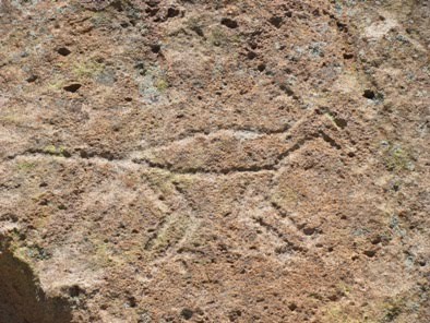
 While petroglyph panels can be found throughout the hike, the best places to find them are near the first ladder, just after the loop portion of the hike begins, and then along the southern portions of the loop as the route travels through the deepest worn sections of incised trail. The petroglyphs at Tsankawi depict figures of humans, animals, birds, four-pointed stars, as well as many other designs and symbols. Although classified as “rock art,” petroglyphs have a much deeper meaning, some known to modern Pueblos, while others have long been forgotten.
As you travel along the top of the mesa hikers will enjoy great views of the surrounding mountains. You may also notice pottery sherds just off the side of the trail in some places. I hope it goes without saying, but the park instructs that you should never disturb any artifacts, and that you should always leave them where you find them.
The people who lived here during the 15th and 16th centuries carved homes out of the soft tuff atop the mesa, and used the canyons below to grow crops. According to the park website, Tsankawi means “village between two canyons at the clump of sharp, round cacti.” The descendents of the Tewa now live in nearby San Ildefonso Pueblo. For a much better understanding of the area and its former inhabitants, hikers should pick-up an interpretive trail guide at the main visitor center. You can also view one online. Here’s looking out from one of the cavates:
 Although classified as “rock art”, petroglyphs have a deeper meaning, some known to modern Pueblos, but others now forgotten. Here are a few examples:

 Hikers should also note that the trail is very exposed to the elements and should not be taken during thunderstorms, or when icy conditions exist. In the summer, make sure you bring plenty of water.
Trail: Tsankawi Loop Trail
RT Distance: 1.5 miles
Elevation Gain: minimal
Max Elevation: 6,665 feet
TH Location: On State Hwy 4, less than 1/4 of a mile from State Hwy 502 (near White Rock)
Map: Bandelier NM Trails Illustrated Map

A Guide to Bandelier National Monument - More than a guide, this book includes a 38 page introduction which gives a brief description, from prehistory, European arrival, to the WWII era and its aftermath. Dorothy Hoard's use of photographs, and cleanly drawn hand sketches to show Bandelier's trails, from the Visitor's Center trailheads, State Road 4, St. Peter's Dome, and Eagle Canyon Pumice Mine trailheads. Dorothy gives the avid trail hiker, and the armchair nature enthusiast a clear idea of what the landscape holds, plus plenty of regional flavor sprinkled in with historical facts and information.


