Showing posts with label Bandelier National Monument. Show all posts

Saturday, June 29, 2013

Tsankawi Loop Trail

Roughly 11 miles north of the main entrance to Bandelier National Monument is a relatively unknown and detached unit of the park known as Tsankawi. Although this area is easy to overlook, visitors to Bandelier shouldn’t pass up a chance to visit this gem. The primary attraction at Tsankawi is the short loop trail that provides access to numerous unexcavated ruins, cave dwellings carved into the soft volcanic tuff, as well as several petroglyphs from the Ancestral Tewa Pueblo that lived here between the 15th and 16th centuries.

The Tsankawi Loop Trailhead is located on NM State Highway 4 less than a quarter-of-a-mile south of State Highway 502, or roughly 11 miles north of the main entrance to Bandelier National Monument. A large gravel parking area is located on the east side of the road. Please note that there are no signs for Tsankawi on Highway 4, though there is a sign on the fence leading into this detached unit of the park. The parking area, which is adjacent to the road, is located just north of the stop light at the intersection of Highway 4 and East Jemez Road near White Rock, New Mexico.

Although the hike is rated as easy, there is some minor rock scrambling involved, as well as three wooden ladders that you’ll have to use in order to move between the upper and lower cliffs. You should also note that you’ll be exposed to several sheer drop-offs along the route, so this may not be suitable for young kids, or those with an intense fear of heights.

After numerous generations of use, many sections of the trail have been worn several inches to several feet deep into the soft tuff (compacted volcanic ash), easily making this the most unique trail surface I’ve ever walked on. The park refers to these segments as “incised trails”.

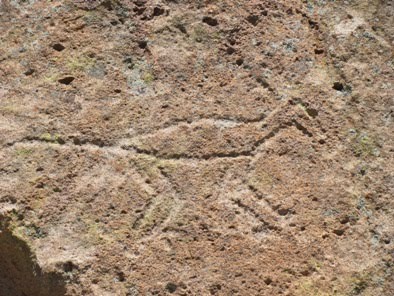
While petroglyph panels can be found throughout the hike, the best places to find them are near the first ladder, just after the loop portion of the hike begins, and then along the southern portions of the loop as the route travels through the deepest worn sections of incised trail. The petroglyphs at Tsankawi depict figures of humans, animals, birds, four-pointed stars, as well as many other designs and symbols. Although classified as “rock art,” petroglyphs have a much deeper meaning, some known to modern Pueblos, while others have long been forgotten.

As you travel along the top of the mesa hikers will enjoy great views of the surrounding mountains. You may also notice pottery sherds just off the side of the trail in some places. I hope it goes without saying, but the park instructs that you should never disturb any artifacts, and that you should always leave them where you find them.

The people who lived here during the 15th and 16th centuries carved homes out of the soft tuff atop the mesa, and used the canyons below to grow crops. According to the park website, Tsankawi means “village between two canyons at the clump of sharp, round cacti.” The descendents of the Tewa now live in nearby San Ildefonso Pueblo. For a much better understanding of the area and its former inhabitants, hikers should pick-up an interpretive trail guide at the main visitor center. You can also view one online. Here’s looking out from one of the cavates:

Although classified as “rock art”, petroglyphs have a deeper meaning, some known to modern Pueblos, but others now forgotten. Here are a few examples:


Hikers should also note that the trail is very exposed to the elements and should not be taken during thunderstorms, or when icy conditions exist. In the summer, make sure you bring plenty of water.


Trail: Tsankawi Loop Trail
RT Distance: 1.5 miles
Elevation Gain: minimal
Max Elevation: 6,665 feet
TH Location: On State Hwy 4, less than 1/4 of a mile from State Hwy 502 (near White Rock)
Map: Bandelier NM Trails Illustrated Map


A Guide to Bandelier National Monument - More than a guide, this book includes a 38 page introduction which gives a brief description, from prehistory, European arrival, to the WWII era and its aftermath. Dorothy Hoard's use of photographs, and cleanly drawn hand sketches to show Bandelier's trails, from the Visitor's Center trailheads, State Road 4, St. Peter's Dome, and Eagle Canyon Pumice Mine trailheads. Dorothy gives the avid trail hiker, and the armchair nature enthusiast a clear idea of what the landscape holds, plus plenty of regional flavor sprinkled in with historical facts and information.


The Cerro Grande Route

Roughly 45 miles northwest of Santa Fe are the ancient ruins and deep canyons of Bandelier National Monument. Designated as a national monument in 1916, Bandelier preserves the homes of the Ancestral Pueblo people.

Archeological surveys show that the Ancestral Pueblos began building permanent settlements in Bandelier by 1150, but had moved to new homes along the Rio Grande by 1550. The main portion of the park, in Frijoles Canyon, contains a number of ancestral homes and dwellings, kivas (circular, half-buried ceremonial structures), rock paintings and petroglyphs.

The last time we visited Bandelier we spent most of our time in Frijoles Canyon. This time we decided to venture a little further out and hike the Cerro Grande Route, a trail located in the fairly isolated northwestern corner of the park. This “Route” offers a much different experience as compared to the rest of Bandelier. Instead of canyons and deserts, the trail explores the subalpine and montane forests of the Jemez Mountains.

Destination for the “Route” is the top of Cerro Grande Peak, Spanish for “Big Mountain”, which at 10,199 feet in elevation is the highest point in the park. The path alternates through open meadows, aspen groves and pine forests. Even in mid-September we still saw a wide variety of wildflowers.

Through the first sections of the hike we noticed a fair amount of evidence of the Cerro Grande Fire that burned roughly 48,000 acres in 2000. The fire started as a controlled burn by the Forest Service, but high winds blew the fire out of control, and eventually destroyed 235 homes in the Los Alamos area. By no means, however, does the fading damage detract from the sublime beauty of the hike.

Be sure to keep an eye out for elk, in addition to the mule deer and pikas we saw along the way.

Most of the climbing comes in the last three quarters-of-a-mile or so. The hike ends at a fairly open meadow at the summit of the peak (which would be called a bald if it were in the Southern Appalachians). From the top you can see the Valles Caldera, the Sangro de Cristo Mountains and the Sandia Mountains. Due to a few trees at the summit, however, the views are much better just a couple hundred feet below the top of the mountain.

Cerro Grande Peak forms part of the rim of the Valles Caldera, a twelve-mile-wide crater that formed when the earth collapsed after a catastrophic volcanic eruption took place here roughly 1.2 million years ago – a geological event very similar to how Yellowstone was created. The eruption was so powerful it pushed out 150 cubic miles of lava, and shot ash as far away to what is now Iowa.

The prominent valley that dominates the view from the top is known as the Valle Grande. In the center of the caldera, and on the far end of the Valle Grande, is Redondo Peak, which, geologically speaking, is a volcanic resurgent dome. Although no longer active, it was formed roughly 70,000 years after the main caldera-forming eruptions occurred.

Today this valley is officially known as the Valles Caldera National Preserve. In 2000 Congress purchased the 89,000-acre unit, known as the historic Baca Ranch, for $100 million. A study conducted in 2009 determined that the Valles Caldera met the high criteria for inclusion in the National Park Service, noting its significant national value and unique, unaltered geology. In February of 2013, U.S. Senators Tom Udall and Martin Heinrich reintroduced legislation to transfer the management of the Valles Caldera National Preserve to the National Park Service. Perhaps someday it will become a national park.

Several movies have been shot in and around the Valles Caldera, including The Gambler, Buffalo Girls, Last Stand at Saber River, The Missing and most recently, Seraphim Falls, which starred Liam Neeson and Pierce Brosnan.

In 2011 another wildfire scorched much of this area after a large aspen tree fell on a power line on nearby private land. The Las Conchas Fire, the largest wildfire in New Mexico history, burned a total of 154,349 acres in Bandelier, the Valles Caldera National Preserve and the surrounding Jemez Mountains. In Bandelier itself, 20,798 acres, or 62% of the park was burned.


Trail: Cerro Grande Route
RT Distance: 4.4 miles
Elevation Gain: 1300 feet
Max Elevation: 10,199 feet
TH Location: 11.6 miles past the entrance to the Bandelier Visitor Center
Map: Bandelier NM Trails Illustrated Map


A Guide to Bandelier National Monument - More than a guide, this book includes a 38 page introduction which gives a brief description, from prehistory, European arrival, to the WWII era and its aftermath. Dorothy Hoard's use of photographs, and cleanly drawn hand sketches to show Bandelier's trails, from the Visitor's Center trailheads, State Road 4, St. Peter's Dome, and Eagle Canyon Pumice Mine trailheads. Dorothy gives the avid trail hiker, and the armchair nature enthusiast a clear idea of what the landscape holds, plus plenty of regional flavor sprinkled in with historical facts and information.