
The hike to Vernal Fall and Nevada Fall begins from the Happy Isles trailhead, located near bus stop 6 in the Yosemite Valley. From the trailhead you’ll proceed up moderately steep terrain along a paved footpath to the Vernal Falls Bridge. Roughly eight-tenths of a mile from the trailhead, the footbridge over the Merced River provides hikers with their first views of Vernal Fall.
After crossing the Merced and walking another two-tenths of a mile, the trail reaches the John Muir Trail junction. From this junction hikers will have the option of completing the loop by continuing in either direction. Although the Mist Trail is much steeper, I highly recommend ascending up this trail first, and then returning back down to the valley via the John Muir Trail. Climbing up the wet, slippery stone steps is much safer than descending them.
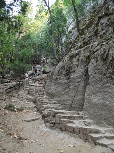
Beyond the junction the trail continues to ascend up moderate terrain. Soon you’ll reach the stone carved steps that the Mist Trail is famous for. You’ll also notice that the views of Vernal Fall continue to improve the closer you get.


From the base of 317-foot Vernal Fall the trail continues to the top of the waterfall. In the process it makes an extremely steep climb of more than 300 feet over several dozen more steep steps carved into the granite cliff wall. As you proceed up the stone stairway you’ll be treated to some outstanding upfront views of the fall.

To continue on towards Nevada Fall, follow the trail as it passes along the south side of Emerald Pool. Soon you’ll pass a junction with the connector trail that leads up to Clark Point. You’ll also pass a slickrock waterslide known as Silver Apron, before crossing over a footbridge that leads over to the north side of the Merced River.
Beyond the footbridge is the former site of the La Casa Nevada hotel. Built in 1870 by Albert Snow, the hotel was famous for its excellent meals before being destroyed by an accidental fire in 1900. To assist tourists to his hotel, Snow constructed a horse trail from Register Rock, which is near the present day Mist Trail / John Muir Trail junction, up to Clark Point, and then back down to the flat between Vernal and Nevada Falls. Here's a photo of the hotel from the Yosemite Research Library:


The John Muir Trail is a world famous long-distance trail that traverses across the High Sierra. The northern terminus is at Happy Isles in the Yosemite Valley, while the southern terminus is located at the top of Mount Whitney, the highest point in the continental United States. In between the trail travels 215 miles while passing through Yosemite, the Ansel Adams Wilderness, Sequoia National Park and Kings Canyon National Park.
Just beyond the junction you’ll have some absolutely stunning views of Half Dome and 7076-foot Liberty Cap towering above Nevada Fall.

Trail: Vernal Fall & Nevada Fall Loop
RT Distance: 6.3 Miles
Elevation Gain: 2000 feet
Max Elevation: 6000 feet
TH Location: Happy Isles Trailhead
Map: Yosemite National Park Trails Illustrated Map

Top Trails: Yosemite features 46 “must-do” hikes in Yosemite National Park, from scenic strolls, to full-day adventures, to spectacular backpacking trips. With at-a-glance information for each hike visitors can determine which hikes are most suitable to their skills, schedules and preferences. The book also provides elevation profiles, detailed maps, as well as information on which trails are child-friendly; where to see giant sequoias, waterfalls, lakes, wildflowers, autumn colors; the best photo opportunities; and which have camping, running or biking opportunities.
No comments:
Post a Comment
Note: Only a member of this blog may post a comment.